


Westheimer Parkway and Clay Road Open to Traffic After Weeks Underwater
Katy, TX (May 10, 2016) Today, Harris County and City of Houston officials announced the opening of Westheimer Parkway through Barker Reservoir (from FM 1093 to South Fry Road), and Clay Road through the Addicks Reservoir (from State Highway 6 to Brittmore Drive), providing some relief to heavy traffic conditions caused by those closures. The sections of those roadways that run through the stormwater detention reservoirs have been impassable due to high water for about three weeks, after torrential rainfall April 17-18 flooded west and northwest Harris County and filled the two reservoirs to record pool levels.
Since the Tax Day/April 2016 storm passed, the U.S. Army Corps of Engineers, Galveston District, has been releasing a steady flow of stormwater from both flood control facilities into Buffalo Bayou in a concerted effort to lower water levels in the reservoirs. This has resulted in the pool levels in the Addicks and Barker reservoirs dropping several feet, which has removed standing water from neighborhood streets behind the Addicks Reservoir and now from Clay Road and Westheimer Parkway.
Motorists are advised to drive with caution on the newly-opened Clay Road and Westheimer Parkway as roadside ditches along both roads are full of water, and will be so for some time until the reservoir pools are substantially lower.
ONGOING ROADWAY IMPACTS
Officials with Harris County, the City of Houston, the Texas Department of Transportation (TXDOT), and the Corps Galveston District have been closely monitoring impacts from the Tax Day Storm on area roadways and public recreation facilities. The remaining roadways that run through the Addicks and Barker reservoirs that are underwater and impassable include:
Addicks Reservoir:
- State Highway 6 is closed from Clay Road to Park Row. TXDOT encourages motorists to use FM 529 as an alternate.
- The north-south North Eldridge Parkway is impassable from Dairy-Ashford to Clay Road.
- The east-west Groeschke Road is impassable from SH 6 to Barker-Cypress Road.
- Other internal roads in the reservoir, including Patterson Road, Bear Creek Drive and War Memorial Street, are impassable.
- All recreational facilities are closed.
Barker Reservoir:
- South Barker-Cypress Road from Westheimer Parkway to FM 1093 is impassable.
- All recreational facilities are closed.
Officials say sections of SH 6 and North Eldridge Parkway that have been closed for weeks should be open to traffic by this weekend, as water in Addicks Reservoir recedes from the roadways. The section of South Barker-Cypress that has been closed through the Barker Reservoir should be open sometime next week. Transportation officials will monitor conditions on those major roadways closely, and will only reopen them after they have been inspected and deemed safe for the travelling public.
NOTE: Residents should be aware that all road openings are subject to change if there is additional rainfall in north/northwest Harris County. Rainfall runoff from areas upstream of Addicks and Barker could increase the reservoirs’ water levels and cause water to again submerge roadways that run through them. It will be several weeks before both reservoirs have drained all stormwater from the Tax Day Storm, and additional rainfall will lengthen that process.
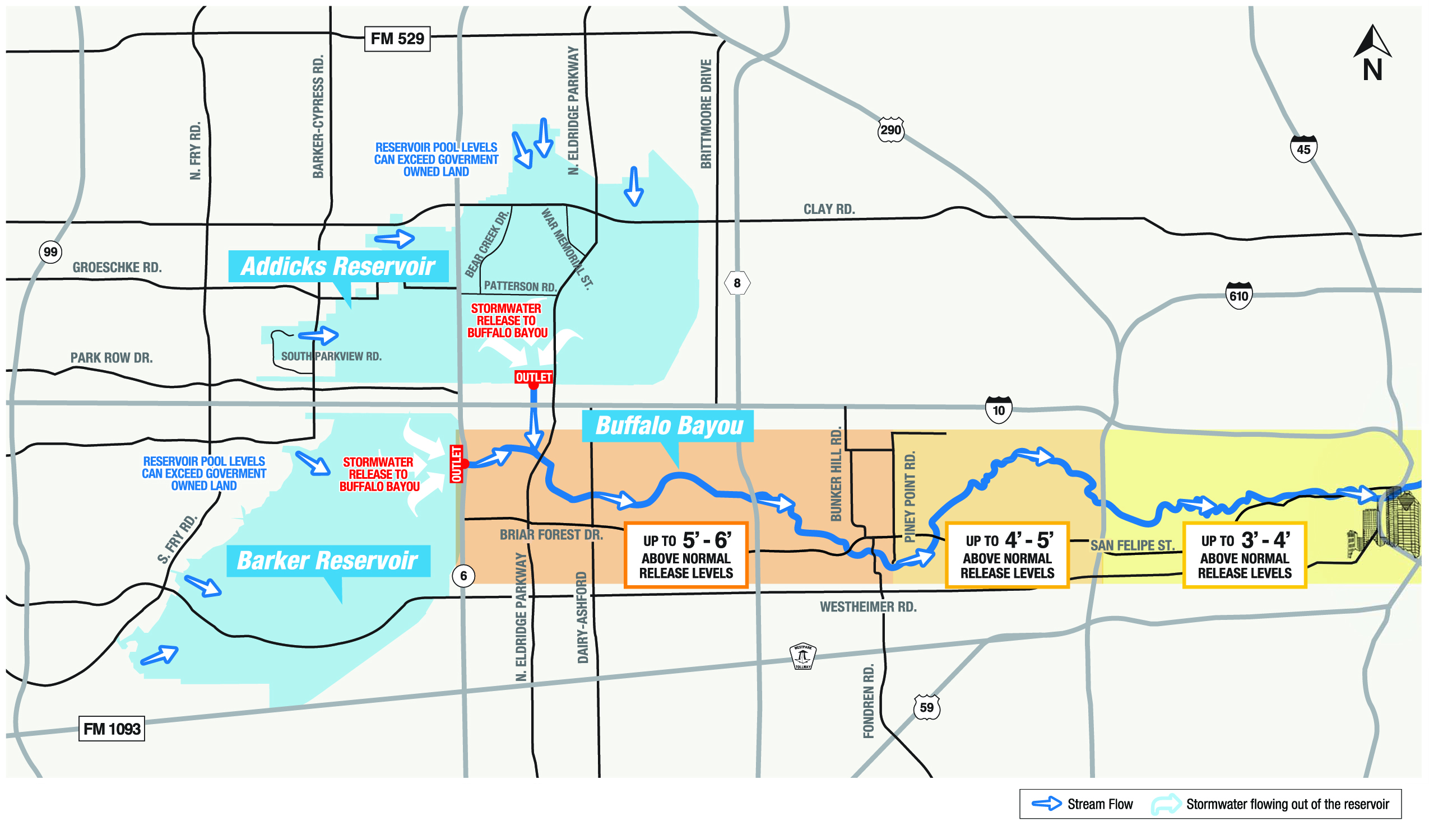
BUFFALO BAYOU IMPACTS
To expedite the emptying of the reservoirs, the Corps Galveston District has increased stormwater releases to Buffalo Bayou by as much as double the normal release rates, which has caused Buffalo Bayou to flow several feet higher than normal from State Highway 6 through downtown Houston. These bayou levels have been significantly lower than the water levels on Buffalo Bayou during the April 17-18 flood.
Public recreation areas along Buffalo Bayou downstream of the dams that are being impacted by increased releases include the low-lying areas in Harris County Precinct 3’s Terry Hershey Park, which is located along Buffalo Bayou from State Highway 6 to the West Sam Houston Tollway, and Buffalo Bayou Park on Buffalo Bayou between Shepherd and Allen’s Landing just west of downtown. Property owners along the bayou will also notice the higher levels.
Park users and residents who live along the bayou are urged to use caution when venturing into those parks and all areas along the bayou’s banks, as there will be higher than usual bayou levels for the next several weeks:
- From State Highway 6 to Piney Point Road the bayou may be up to 5 to 6 feet above normal release levels and some low-lying trails in Terry Hershey Park will have water on them.
- From Piney Point Road to Loop 610, the bayou may be up to 4 to 5 feet above normal release levels.
- From Loop 610 to downtown, the bayou may be up to 3 to 4 feet above normal release levels and there could be water in low-lying sections of Buffalo Bayou Park.
SAFETY ALERT: RESIDENTS ARE ADVISED NOT TO DRIVE OR WALK INTO HIGH WATER ON STREETS; NOR TO BOAT OR SWIM ON BUFFALO BAYOU, OR ANY BAYOU OR CREEK FOR THAT MATTER. BAYOU AND CREEK WATER LEVELS ARE HIGH THROUGHOUT THE COUNTY AND THEIR CURRENTS ARE SWIFT AND DANGEROUS.
ABOUT THE RESERVOIRS
Constructed in the 1940s, both reservoirs are normally kept dry to preserve their overall capacity to impound storm water and reduce flood levels in Buffalo Bayou. When a rain event occurs, the gates are closed on the Addicks and Barker dams to reduce flooding below the reservoirs. When the downstream runoff has receded to non-damaging stages, reservoir operations resume, the gates are opened, and water is released.
GRAPHIC BELOW ILLUSTRATES WATER FLOW BEHIND THE RESERVOIRS; AND WATER RELEASES INTO BUFFALO BAYOU
The process of determining the possibility for a release and the amount of a release is a constant process. If the forecast calls for rain, there are no releases. If the forecast is clear skies and the prediction for rain is zero, the Corps begins releasing stormwater. Anything in between increases the difficulty in making that decision.
For information about the Addicks and Barker Reservoir operations, call the U.S. Army Corps of Engineers Galveston District at 409-766-6377. For current Addicks and Barker Reservoir water levels and current water levels along Buffalo Bayou go to www.harriscountyfws.org
To learn more about the Addicks and Barker Dam Safety Program, or for more news and information about the U.S. Army Corps of Engineers Galveston District, visit www.swg.usace.army.mil, www.facebook.com/GalvestonDistrict or www.twitter.com/USACEgalveston.
About the Harris County Flood Control District
The Harris County Flood Control District provides flood damage reduction projects that work, with appropriate regard for community and natural values. With more than 1,500 bayous and creeks totaling approximately 2,500 miles in length, the Flood Control District accomplishes its mission by devising flood damage reduction plans, implementing the plans and maintaining the infrastructure.